Summer Update from the IWC Graduate Student Research Grant Program: Nathan Young

Post submitted by Nathan Young, a PhD student co-majoring in Geology and Environmental Science here at Iowa State University.

Over the past 30 years, computer simulations of groundwater flow have become a standard tool for investigating water quality and quantity issues across the globe. Because of a number of limitations, ranging from data availability to available computer power, these simulations (or “models”) contain a number of simplifying assumptions that prevent them from being perfect representations of the location being studied. For instance, if the subsurface was composed primarily of sand with some gravel mixed in, we may tell the model that the subsurface is only composed of sand to simplify the model and make it run faster. While these assumptions may be acceptable under most circumstances, several common assumptions made about the subsurface in Iowa may in fact impede our understanding of how water and nutrients are moving throughout the state. In Iowa’s till dominated watersheds, the subsurface is commonly treated as a fairly homogenous low-permeability material, while in reality, ultra-small-scale cracks (or fractures) present in this material provide pipe-like pathways through which water and nutrients can move very rapidly. These fractures are often omitted from models due to the massive amount of computer power required to include them in the type of watershed-scale investigations that would be conducted for the purposes of evaluating regional water quality.

In spring 2017, I was awarded funding in the Iowa Water Center Graduate Student Supplemental Research Competition for my project titled, “Simulation of Watershed-Scale Nitrate Transport in Fractured Till Using Upscaled Parameters Obtained from Till Core.” My research seeks to accomplish two goals: to develop a method to include fractures in watershed-scale models, and then to evaluate the extent to which these ultra-small-scale fractures enhance groundwater flow and nutrient transport at the watershed scale.

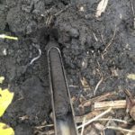
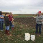
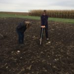
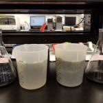
This past summer I have made significant progress on my project on a number of fronts. My laboratory experiments on a series of 16x16x16 cm sediment samples excavated from the Dakota Access Pipeline trenches are ongoing, but they are progressing forward. I am currently conducting flow experiments on the samples using groundwater spiked with a chemical tracer. These samples contain small-scale cracks, called fractures, which provide pathways for very rapid movement of fluid and tracer in what would otherwise be a largely impervious material. By measuring the flow rate of fluid coming out of the sample, as well as the concentration of tracer that this effluent contains, I can quantify to what degree these fractures are enhancing flow within the sample. Early results of this work show that as we move deeper in the subsurface, water moves through the samples more slowly (which is what we would expect to see) yet these flow rates are still higher than we would find if the samples did not contain fractures. Furthermore, tracer concentrations in the sample effluent indicate that the fractures are providing preferential pathways for the tracer to flow through, resulting in tracer exiting the sample much sooner than if it were unfractured. I have been fortunate to have the assistance of two undergraduates, Jay Karani ’19, and Kate Staebell ’17, in setting up these experiments and analyzing the resulting output. This work would have taken much longer without their help!

I have also been working to develop a set of new computational methods that will allow for the role that these fractures play in groundwater flow and solute transport to be included in watershed-scale computer models. Previously, accounting for groundwater flow in fractures was too computationally intensive to include in models larger than the size of a small field. Yet the early results of my work suggest that we may have found a method to circumvent this computational limitation by computing a new set of flow parameters using sophisticated, small-scale groundwater flow simulations and field data.  I presented some preliminary results of this work at the 2017 MODFLOW and More conference in Golden, Colorado, this past May, and was awarded 2nd place for graduate student presentations. A short paper on this work was also published in the conference proceedings. I am currently finalizing my results in preparation for a talk I will be giving at the Geological Society of America’s National meeting in Seattle later this month. I am also in the process of writing up the results for publication, and hope to have one of two manuscripts ready for submission by the end of the semester.

Finally, I was invited to visit Laval University in Quebec City, Canada this past August to work with Dr. René Therrien, a professor in the Department of Geology and Geological Engineering who developed the groundwater model I am using in my research. With the help of Dr. Therrien and his research group, I was able to accomplish in two weeks what would have likely taken me three months on my own. I have already been invited back to work with them again in summer 2018. We are working together to write a grant proposal to secure funding for that visit. I am confident that continued work with my collaborators at Laval University will enable me to include more detail in my study area, Walnut Creek watershed, into the overall model of the watershed I am currently building.

Get to know your soil

Photos of the 2017-2018 Agronomy in the Field cohort for Central Iowa at the ISU Field Extension Education Lab. Photos by Hanna Bates.

An education in soil sampling

Last week I attended Agronomy in the Field, led by Angie Reick-Hinz, an ISU field agronomist.  The workshop focused on soil sampling out in a field. The cohort learned a lot of valuable insight into not only the science of soil sampling, but also practical knowledge from out-in-the-field experiences.

Taking soil samples in a field is critical in making decisions about fertilizer, manure, and limestone application rates. Both over and under application can reduce profits, so the best decision a farmer can make is based on a representative sample that accurately shows differences across his/her fields.

What do you need?

  • Sample bags
  • Field map
  • Soil probe
  • Bucket

When do you sample?

After harvest or before spring/fall fertilization times. Sampling should not occur immediately after lime, fertilizer, or manure application or when soil is excessively wet.

Where do you sample?

Samples taken from a field should represent a soil area that is under the same type of field cultivation and nutrient management. According to ISU Extension, the “choice of sample areas is determined by the soils present, past management and productivity, and goals desired for field management practices.”* See ISU Extension resources for maps and examples for where in the field to take samples.

Most importantly…

Like with everything that happens out in the field, it is important to keep records on soil testing so that you can evaluate change over time and the efficiency of fertilizer programs. As we say at the Iowa Water Center, the more data, the better! The more we learn about the soils, the better we can protect and enhance them. Healthy soils stay in place in a field and promote better crop growth by keeping nutrients where they belong during rain events. Not only can we monitor soil from the ground with farmers, but with The Daily Erosion Project. These combined resources, with others, can provide the best guidance in growing the best crop and protecting natural resources.

Interested in Agronomy in the Field? Contact Angie Rieck-Hinz at amrieck@iastate.edu or 515-231-2830 to be placed on a contact list.

* Sawyer, John, Mallarino, Antonio, and Randy Killorn. 2004. Take a Good Soil Sample to Help Make Good Decisions. Iowa State University Extension PM 287. Link: https://crops.extension.iastate.edu/files/article/PM287.pdf

Capture

Hanna Bates is the Program Assistant at the Iowa Water Center. She has a MS in Sociology and Sustainable Agriculture from Iowa State University. She is also an alumna of the University of Iowa for her undergraduate degree. 

University of Iowa: A case study of flood response


In honor of construction starting soon to replace one of the last University of Iowa buildings damaged by the 2008 floods, we have decided to highlight a history of flood infrastructure investments at the university .

Just one-year shy of a decade since the 2008 floods, the final plans have been approved for a new facility for the University of Iowa Museum of Art. Like Hancher Auditorium, the music school, the library, and the Iowa Memorial Union, among about seventeen other buildings (Connerly et al 2017), the art museum was a significant loss to the university that scattered its 14,000-estimated piece collection to new locations on and off campus.

According to Connerly et al 2017, damages and recovery were estimated to be $743 million and is the highest costing disaster recovery in Iowa. As a public institution located in a floodplain area, it has had a history of flood preparation and response since its inception in 1847. As their article explains, the flooding brought up many critical questions, including: “why did the University construct important new buildings, some of them iconic, within the floodplain?” and how can the university cope with future natural and human-made flooding?

To answer the first question, the university built where they did predominantly because they had few options. The risk of flood also gave the appearance of being manageable at the time and policies for flood mitigation and subsidies were more risky than they appeared to be (Connerly et al 2017). The university started on a small four block area east of the Iowa River. The university and the City of Iowa City grew concurrently causing buildings to be placed closer and closer to the river. In 1905, the university commissioned a master plan by the Olmsted Brothers that included riverfront property, but its use would only be for recreation and parks (Connerly et al 2017). Land acquisition advisement by the Olmsteds was illustrated in the following:

“The Olmsted Brothers emphasized the need to acquire land that would be of value to the University, even if it costs more. They stated, ‘‘the process of acquisition of additional land must evidently go on indefinitely, but some other motives than those of convenience and cheapness should be kept in mind and should often have more weight than those.” (55)

The construction on the floodplain started with the Iowa Memorial Union (IMU) in the 1920s and then grew to include the arts campus. Construction for a fine arts building was originally planned for a site north of the IMU, but an agreement could not be reached for a price. Instead, the campus was developed on acquired land that was a wetland formerly used as a city landfill by the river (Connerly et al 2017).

The wetlands were filled and the buildings were constructed to be above recorded flood level data available at the time and levees were constructed on the river. Later, these efforts included the university’s support of building the Coralville Reservoir by the Army Corps of Engineers, in which the president of the university at that time stated, “the Reservoir will make possible a program for the permanent development of the river front through the University campus” ( Connerly et al 2017, p.58). The campus was growing in two halves on the east and west side of the river. Development in-between would unite the two pieces, especially when considering there were little other places to build.

This culminates in the issue of what Connerly et al (2017) describes as the “safe development paradox.” This term is used to describe the federal support for levees, dams, disaster aid programs, and other assistance that spurred development in the floodplains. By providing a safety net with federal assisted water-related control, recovery, and insurance, federal policy enabled development that came at a cost with the 1993 and 2008 floods.

How can the university cope with natural and human-made flooding for the future?

To answer this question, the university has responded to the 2008 floods by re-purposing or completely rebuilding new facilities that are more resilient to withstanding future flooding using scientific modelling as a tool. The recovery efforts include a multitude of partnerships that choreograph their work around where FEMA compliance and insurance policies reach within each building. The university voluntarily chose to conduct a campus-wide flood mitigation strategy that is in progress. This strategy includes elevated sidewalks, supports for temporary flood walls, building pumping systems, and removable external walls. The university has also rebuilt two buildings away from their original locations. As seen above, these strategies have been tested with the rise in water levels in 2013.

In review, the tumultuous history of flooding infrastructure contains valuable lessons. Resilience, which is at the core of what public infrastructure is trying to achieve, is the ability to spring back from disasters. The university that came out on the other side of the 2008 floods is one that utilizes water research and technology using scientific methods and demonstrates that there is room for improvement in state and federal policies and procedures. As a result, when future flooding occurs, we will all be better able to respond.

Connerly, Charles, Laurian, Lucie, Throgmorton, James. 2017. Planning for Floods at the University of Iowa. Journal of Planning History 16(1): 50-73.

Capture
Hanna Bates is the Program Assistant at the Iowa Water Center. She has a MS in Sociology and Sustainable Agriculture from Iowa State University. She is also an alumna of the University of Iowa for her undergraduate degree. 

Summer Update from the IWC Graduate Student Research Grant Program: Emily Martin

Post submitted by Emily Martin, MS Environmental Science student at Iowa State University

Intensive farming and heavy nutrient application in the Midwest coupled with an extensive subsurface tile drainage network frequently leads to excessive nutrients in surface waters. As a result, heavy amounts of nitrogen and phosphorus has become a critical issue for policy and water research.

In spring 2017, I was awarded funding in the Iowa Water Center Graduate Student Supplemental Research Competition for my project titled, “Enhancing phosphate removal in woodchip bioreactors.” This project is conducted under advisement of Dr. Michelle Soupir at Iowa State University. A bioreactor is a subsurface trench along the edge of the field that can be filled with a range of different carbon sources. They are identified as a practice to help mitigate nutrient loss to flowing water systems, and so they deserve further research to understand their full capacity to capture water nutrients.

The goal of the project is to evaluate the ability of woodchip bioreactors to remove phosphorous by adding biochar as a phosphate (P) amendment to bioreactors. Objectives of the study are (1) to assess the effectiveness of different amendments on P removal in bioreactors and (2) to analyze the effect of influent P on overall removal.

We broke the project down into two main parts: a P sorption study and a column study. We completed part one during the month of June using 18 different types of biochar. The biochar was made by Bernardo Del Campo at ARTichar using three different temperatures of slow pyrolysis, 400°C, 600°C, and 800°C. We used six different types of biomass provided by the BioCentury Research Farm and the City of Ames, which are: switchgrass, corn stover, ash trees, red oak, mixed pine, and loblolly pine. The goal was to test a variety of biomass to see which would perform best as a P amendment and under which pyrolysis conditions they would function best.

Biochar is made using a process called pyrolysis. Pyrolysis is the burning of plant materials in a low to no oxygen chamber in order to “activate” the carbon structures that exists naturally within plants. The highly structured form of carbon rings in plants is desired for its stability and potential to adsorb or bind with chemicals, including phosphate and nitrate. There are two main types of pyrolysis: fast and slow, which refers to the amount of time the biomass remains in the pyrolysis chamber. Fast pyrolysis can be used to create biochar, but the yield is lower than slow pyrolysis. The temperature of pyrolysis can impact how the biochar interacts with different chemicals. In order to test these effects, we used three different temperatures when making our biochar.

Results from the P sorption study showed a few patterns. The main take away is that none of the biochars we tested adsorbed P exceptionally well; however, of the biochars we tested, the following were our top five P adsorbers:

  1. Corn stover @ 800°C
  2. Loblolly pine @ 600°C
  3. Red oak @ 600°C
  4. Switch grass @ 800°C
  5. Mixed pine @ 400°C

Because none of the biochars performed well in our P sorption test, we had to make a decision for the second part of the project. We came up with two options: (1) find new biomass and run the P sorption test again, or (2) test how well all 18 biochars remove nitrate from water. We chose option two and have begun nitrate batch tests, which will run throughout July. The batch tests are being run in one liter flasks and are tested at 4, 8, 12, and 24 hours to simulate woodchip bioreactor residence times found in the field.

After the nitrate batch test is complete, we will analyze results and decide if we will move forward with option one and see how other biomasses perform in a P sorption test.

Check back later on to learn more about the progress of this project!


2018 Iowa Water Conference – Call for Abstracts!

18 IWC wordmark.png

Success in water-related work, whether it is out in the farm field, a backyard, or in city infrastructure, cannot be achieved alone. It is done by a community and for a community. With that in mind, the Iowa Water Conference Planning Committee is happy to announce the theme for the 2018 Iowa Water Conference: “Our Watershed, Our Community.” This theme was inspired by the large, complex network of water-related professionals in Iowa that support local watershed work.

We invite water professionals, researchers, and graduate students to submit presentation abstracts centered around the theme of community in water. Through these presentations, applications should share success stories, challenges, and research that supports a foundation of community at the watershed-level.

The call for presentations, including instructions for submission, can be found here. Questions can be directed to Hanna Bates at hbates@iastate.edu. We look forward to learning about your watershed experience!

Caring for Creation & Sister Water

Caring for Sister Water was one of many creation care efforts that came with the founding of Prairiewoods 20 years ago. These efforts included two infiltration ponds that hold much of the water that runs off our parking lots and roadways, as well as numerous trees and plants with extensive root systems that hold and cleanse water. After the Cedar Rapids floods of 2008, we doubled our efforts to address storm water concerns— we installed permeable pavers, hosted rain barrel classes and identified four storm water culverts that drain on our land. Varying degrees of erosion meant that all four of these culvert areas needed attention.

Continue reading

Soil – Agriculture’s Reservoir

Post submitted by Hanna Bates, Program Assistant for the Iowa Water Center

The soil is like a sponge that holds water so it is available when crops need it. Wetter soil at the surface prevents deeper infiltration and so water is lost as surface runoff. Not only this, but soil moisture is also a variable that influences the timing and amount of precipitation in a given area. This is due to the impact it has on the water cycle. This cycle circulates moisture from the ground through evaporation and plant transpiration to the atmosphere and back to the ground again through precipitation. Therefore, the amount of water stored in the soil can affect the amount of precipitation received during the growing season.

esa.PNG
Satellite imaging from the European Space Agency. The center figure depicts imaging derived from SMOS.

According to Hornbuckle (2014), “we enter each growing season ‘blind’ as to whether or not there will be enough soil moisture and precipitation to support productive crops.” If there were a way to document and record water storage in the soil besides field measurements, we would have a better ability to predict future weather patterns and therefore, make better field decisions. Satellite remote sensing tools such as the European Space Agency’s Soil Moisture and Ocean Salinity (SMOS) and NASA’s Moisture Active Passive (SMAP) can be used to take such measurements. Before these tools can be used to estimate water storage and improve weather and climate predictions, researchers must compare them to what is actually measured within the soil. This process of confirming accuracy of a tool is called validation.

A project led by Dr. Brian Hornbuckle, and funded by the Iowa Water Center in 2014, sought to improve and validate SMOS and SMAP in near-surface soil moisture observations of Iowa. Hornbuckle used a network of soil moisture measurements located in the South Fork Watershed as a standard to validate the accuracy of SMOS and SMAP. At each site, soil moisture and precipitation was measured.

Some of the results of this research project are presented in a 2015 article published in the Journal of Hydrometeorology.  Rondinelli et al. found that SMOS and the network of soil moisture measurements detect different layers of the soil. SMOS takes measurements of the soil surface while the network observes a deeper level of soil. These results will allow scientists to better evaluate the accuracy of measurements from SMOS and SMAP and ultimately enhance our understanding of the water content of the soil surface.  As noted earlier, it is this layer of the soil that determines how much precipitation is lost to surface runoff.

In a subsequent study published in 2016, Hornbuckle et al. published further results that indicate new ways of using SMOS. Researchers found that SMOS can be used to look at water in vegetation, as opposed to water in the soil.  Hence SMOS might be used in the future to observe the growth and development of crops, and perhaps estimate yield and the time of harvest as opposed to conducting field surveys from the ground. It also has the potential to measure estimates of the biomass produced during the growing season, which could be useful to reach bioenergy production goals.

Research like this demonstrates that a single tool can be used in multiple ways to better understand our landscape. Not only this, but preliminary studies of SMOS also show that it is important to verify the accuracy of tools before relying on them. Like all research, the work is not done to identify all the potential uses for SMOS and SMAP.  A new NASA grant, in partnership with the Iowa Flood Center, will help get researchers even closer to making satellite measurements a useful, scientific tool to understand water near the soil surface.

References

Hornbuckle, Brian K. “New Satellites for Soil Moisture: Good for Iowans!.” A Letter from the Soil & Water Conservation Club President (2014): 20.

Hornbuckle, Brian K. Jason C. Patton, Andy VanLoocke, Andrew E. Suyker, Matthew C. Roby, Victoria A. Walker, Eswar R Iyer, Daryl E. Herzmann, and Erik A. Endacott. 2016. SMOS optical thickness changes in response to the growth and development of crops, crop management, and weather. Remote Sensing Environment (180) 320-333.

Rondinelli, Wesley J., Brian K. Hornbuckle, Jason C. Patton, Michael H. Cosh, Victoria A. Walker, Benjamin D. Carr, Sally D. Logsdon. 2015. Different Rates of Soil Drying after Rainfall Are Observed by the SMOS Satellite and the South Fork in situ Soil Moisture Network. Journal of Hydrometeorology. April 2015.


View from my Windshield: Observations of soil erosion across Iowa

For the past couple of weeks, I have been on the road across Iowa. These trips vary in their purpose, but one thing that remains the same is the evident erosion in the fields along my travels. Regardless of where I am – whether it is in the Loess Hills visiting family or in the Des Moines Lobe for a meeting – spring rains have revealed that there are deep cuts in the bare brown soils where lush, even soils used to be.

Continue reading

Planning for Watershed Success in Eastern Iowa

11108858_986702184682588_7720700685004655431_n
Attendees of the Indian Creek Watershed open house discussing the map of the watershed. Photo from the Indian Creek Watershed Facebook page.

Post edited by Hanna Bates, Program Assistant at the Iowa Water Center

This week, we chatted with Jennifer Fencl, the Solid Waste & Environmental Services Director at The East Central Iowa Council of Governments (ECICOG). Fencl works to bring eastern Iowa stakeholders together to better manage their natural resources and to create a long-term investment in their community. Below are a few highlights from our conversation that outlines some of the behind-the-scenes work in watershed planning.

Please describe your work in watershed management in Iowa.

The East Central Iowa Council of Governments (ECICOG) became involved in watershed management in 2011 when the City of Marion requested assistance in applying for Watershed Management Authority Formation grant funding from the Iowa Economic Development Authority (IEDA) for the Indian Creek watershed. The Indian Creek Watershed Management Authority (ICWMA) was formed under Iowa Code 28E and 466B in August 2012 with 6 of the 7 eligible jurisdictions agreeing to plan for improvements on a watershed level. Funds were made available in 2013 by the IEDA to complete watershed management plans to address flood risk mitigation and water quality. The ICWMA received one of the three planning grants and engaged in a multi-jurisdictional planning approach facilitated by ECICOG in partnership with several local, state, and federal agencies. The resulting Indian Creek Watershed Management Plan (ICWM Plan) identifies strategies and recommendations for stormwater management and water quality protection, including specific implementation activities and milestones. The ICWM Plan was completed and presented to the public in June 2015 and adopted by all six of the ICWMA members at policy maker meetings during July and August of 2015.

As the ICWMA Plan was wrapping up, the City of Coralville requested ECICOG’s assistance in forming a WMA for the Clear Creek watershed. In this case, Coralville was willing to sponsor the WMA formation and planning grant application services. The Clear Creek Watershed Coalition (CCWC) formed as a WMA under Iowa Code 28E and 466B in October 2015 with all 9 of the eligible jurisdictions joining. ECICOG secured DNR watershed planning funds early in 2016 and the CCWC is mid-way through their planning process. Fortunately, the Clear Creek watershed was one of the eight watersheds selected for the Iowa Watershed Approach HUD grant project. The additional watershed planning funds from the HUD grant will add significantly to the resulting watershed plan.

In early 2016, the Middle Cedar Watershed Management Authority (MCWMA) was on its way to formally becoming a WMA and needed some help in completing the agreement filing, developing by-laws, and organizing the Board of Directors. ECICOG assisted the MCWMA in forming under Iowa Code 28E and 466B in June 2016 with 25 of the 65 eligible jurisdictions joining. The MCWMA is one of the eight watersheds selected for the Iowa Watershed Approach HUD grant project.

What are the challenges and rewards in doing work with watershed management?

One challenge that became clear in the Indian Creek process was the disconnect between the watershed (technical) assessment and the local stakeholders. That gap must be bridged to develop meaningful, locally-based goals and implementation strategies.  For me, the reward is watching the interaction between perceived “enemies” (urban/rural; big city/suburb; ag producer/government type) and bringing skeptical people into the process to develop an actual plan… that they ultimately agree to.

What kinds of stakeholders are involved in developing a watershed management plan?

It is critical to include the local Soil and Water Conservation District, government representatives, and the landowners (both urban & rural, flood impacted if possible) in developing goals and strategies. I believe that it is also important to identify the ‘experts’ in your watershed, both locally and from state agencies, early on and have them provide input on what assessment activities and planning services are really needed from an outside consultant. There is a role for everyone to play.

What are the basic steps in putting together a watershed management plan?

Here is my road map:

  1. Invite participation
  2. Identify resource concerns
  3. Assemble experts
  4. Complete assessment work
  5. Present the assessment to a broad list of stakeholders (need good interpreters)
  6. Develop goals, define implementation strategies, and prioritize the strategies
  7. Compile the plan and present the plan for comment
  8. Shop the plan for formal adoption by policy making board/councils.

What is one piece of advice you’d give to those wanting to develop a watershed plan for their community?

Run… kidding, sorta.  Seek help from the Iowa Department of Natural Resources and Iowa Department of Agriculture and Land Stewardship basin coordinators first, and then gauge the interest of the other entities in the watershed. You need to find some champions to help smooth the way for local elected officials.

Development of a Watershed Project Extension

The Boone River Watershed Nutrient Management Initiative project has been granted additional funding from Iowa Department of Agriculture and Land Stewardship (IDALS). This is in order to extend the project for another three years to increase the use of conservation and water quality practices in Prairie and Eagle Creek Watersheds. In these projects, we will continue working towards meeting Iowa’s Nutrient Reduction Strategy goals. The extension process involved writing a new grant application based on the lessons learned from our first three years.

Continue reading