In the webinar, “Agriculture and Climate Change in Iowa and the Midwest – Adaptation, Mitigation and Decision Making,” Todey will provide an overview of several major climate change issues impacting agriculture in the region.
Continue readingSoil Resilience and Climate Change
There is a continual dialog about the food required to feed a population of nine billion people by 2050 and the changing climate and the impacts on food production and food security.
Continue readingDennis Todey’s Twitter Takeover
Dennis Todey, the director of the United States Department of Agriculture (USDA) Midwest Climate Hub, took the reigns of our Twitter account on April 23rd to discuss the ongoing conversation around climate and water issues in Iowa.
The climate hubs were created in 2014 by the USDA and consist of 10 hubs spread around the United States. Each hub develops the latest information regarding topics including climate change, agriculture and forestry. The hubs also help to develop new tools, work on adaption efforts in ag-climate change and several other areas of regional agriculture and forestry.
The Midwest Climate Hub (MCH) includes the states: Minnesota, Iowa, Missouri, Wisconsin, Illinois, Indiana, Michigan and Ohio. A main objective of the MCH is working hand in hand with the National Weather Service Climate Prediction Center (NWSCPC) to compare and contrast current information with the information presented by NWSCPC to make accurate predictions of future climate issues. The MCH also revolves heavily around work with agriculture climate issues, especially impacts on specialty crops.
The MCH also collaborates with many services, including federal and regional partnerships. Some of these partnerships include National Oceanic and Atmospheric Administration (NOAA), High Plains Regional Climate Center (HPRCC), National Drought Mitigation Center, USDA Farm Service Agency and USDA National Agricultural Statistics Service. The MCH works with many extension programs across the Midwest as well to discuss climate issues and land grant programs.
Todey explains that one of the largest issues the Midwest sees in regards to climate is increased precipitation. Precipitation totals have increased 10-15% in the central United States in the last 100 years, with this causing wetter springs and falls that lead to various agriculture issues including floods and increased surface runoff. With more wetness comes with the possibilities of soil and nutrient loss, as well as an interest for more agriculture draining systems.

Picture attached in tweet:

Of course, another “hot” topic in this discussion was the increase in temperature. The temperature is rising year by year, with positives and negatives in result. One positive is that now Iowa winters are not as painful – it is still cold, but not as severe or lasting as long.

Pictures attached in tweet:


To end the Twitter takeover, Todey inquired about the community’s favorite weather based songs. Here is a link to a Spotify playlist of all of the replies – as well as some of my own additions.
Todey received his Bachelor of Science in meteorology from Iowa State University, his Master of Science in meteorology from South Dakota School of Mines and Technology and earned his PhD in agriculture meteorology from Iowa State University. He served as the South Dakota state climatologist for 13 years at South Dakota State University and has been in Iowa working with the USDA since 2016.
You can follow Dennis’ personal Twitter account, @dennistodey, the USDA Climate Hub Twitter account, @USDAClimateHubs, and of course, the Iowa Water Center account @IowaWaterCenter to see the Twitter takeovers in live action.
Soil – Agriculture’s Reservoir

Post submitted by Hanna Bates, Program Assistant for the Iowa Water Center
The soil is like a sponge that holds water so it is available when crops need it. Wetter soil at the surface prevents deeper infiltration and so water is lost as surface runoff. Not only this, but soil moisture is also a variable that influences the timing and amount of precipitation in a given area. This is due to the impact it has on the water cycle. This cycle circulates moisture from the ground through evaporation and plant transpiration to the atmosphere and back to the ground again through precipitation. Therefore, the amount of water stored in the soil can affect the amount of precipitation received during the growing season.
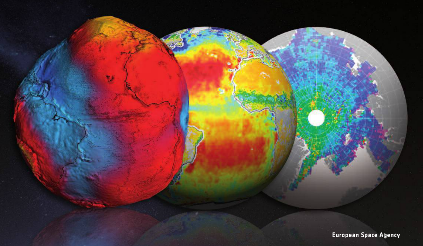
According to Hornbuckle (2014), “we enter each growing season ‘blind’ as to whether or not there will be enough soil moisture and precipitation to support productive crops.” If there were a way to document and record water storage in the soil besides field measurements, we would have a better ability to predict future weather patterns and therefore, make better field decisions. Satellite remote sensing tools such as the European Space Agency’s Soil Moisture and Ocean Salinity (SMOS) and NASA’s Moisture Active Passive (SMAP) can be used to take such measurements. Before these tools can be used to estimate water storage and improve weather and climate predictions, researchers must compare them to what is actually measured within the soil. This process of confirming accuracy of a tool is called validation.
A project led by Dr. Brian Hornbuckle, and funded by the Iowa Water Center in 2014, sought to improve and validate SMOS and SMAP in near-surface soil moisture observations of Iowa. Hornbuckle used a network of soil moisture measurements located in the South Fork Watershed as a standard to validate the accuracy of SMOS and SMAP. At each site, soil moisture and precipitation was measured.
Some of the results of this research project are presented in a 2015 article published in the Journal of Hydrometeorology. Rondinelli et al. found that SMOS and the network of soil moisture measurements detect different layers of the soil. SMOS takes measurements of the soil surface while the network observes a deeper level of soil. These results will allow scientists to better evaluate the accuracy of measurements from SMOS and SMAP and ultimately enhance our understanding of the water content of the soil surface. As noted earlier, it is this layer of the soil that determines how much precipitation is lost to surface runoff.
In a subsequent study published in 2016, Hornbuckle et al. published further results that indicate new ways of using SMOS. Researchers found that SMOS can be used to look at water in vegetation, as opposed to water in the soil. Hence SMOS might be used in the future to observe the growth and development of crops, and perhaps estimate yield and the time of harvest as opposed to conducting field surveys from the ground. It also has the potential to measure estimates of the biomass produced during the growing season, which could be useful to reach bioenergy production goals.
Research like this demonstrates that a single tool can be used in multiple ways to better understand our landscape. Not only this, but preliminary studies of SMOS also show that it is important to verify the accuracy of tools before relying on them. Like all research, the work is not done to identify all the potential uses for SMOS and SMAP. A new NASA grant, in partnership with the Iowa Flood Center, will help get researchers even closer to making satellite measurements a useful, scientific tool to understand water near the soil surface.
References
Hornbuckle, Brian K. “New Satellites for Soil Moisture: Good for Iowans!.” A Letter from the Soil & Water Conservation Club President (2014): 20.
Hornbuckle, Brian K. Jason C. Patton, Andy VanLoocke, Andrew E. Suyker, Matthew C. Roby, Victoria A. Walker, Eswar R Iyer, Daryl E. Herzmann, and Erik A. Endacott. 2016. SMOS optical thickness changes in response to the growth and development of crops, crop management, and weather. Remote Sensing Environment (180) 320-333.
Rondinelli, Wesley J., Brian K. Hornbuckle, Jason C. Patton, Michael H. Cosh, Victoria A. Walker, Benjamin D. Carr, Sally D. Logsdon. 2015. Different Rates of Soil Drying after Rainfall Are Observed by the SMOS Satellite and the South Fork in situ Soil Moisture Network. Journal of Hydrometeorology. April 2015.
The Fifth [Business] Day of Christmas: The Next Generation of Water Professionals
On the fifth [business] day of Christmas, the Iowa Water Center gave to me…a description of the breakout session The Next Generation of Water Professionals.
The following presentations will take place at the Iowa Water Conference in Ames on the afternoon of Wednesday, March 23, 2016. Registration for the conference will open in January.
This breakout session is built a little differently than the other tracks because it IS different: The Next Generation of Water Professionals is being planned by students from the University of Iowa and Iowa State University. It’s designed by the students with students in mind, but everyone at the conference is welcome to attend. The students have four, 30 minute blocks just like everyone else, but they’re mainly focusing on two topics: climate and communicating science.
The session will be set up to have Christopher J. Anderson from Iowa State University give a presentation on climate science, and following this presentation, an interactive and engaging discussion on the impact of climate change predictions on the future of water research and water management. After the break, the students will hear from Pat Boddy of RDG Planning and Design as well as Dr. Dara Wald from Iowa State University’s Greenlee School of Journalism as part of a panel discussion on communicating science issues to the general public, particularly focused on climate and sustainability.
This session is a new feature of the Iowa Water Conference, and we’re excited to offer a venue for college students interested in water to meet and network. If you’re a student and are interested in learning more about this session and the other students attending the conference, contact Melissa Miller at millerms@iastate.edu.