We ask Dan Gilles, Water Resources Engineer from the Iowa Flood Center, the question: What is a 100-year flood?
Sermet Selected as a Recipient for the Iowa Water Center’s Research Grant Competition
Ames, Iowa – The Iowa Water Center (IWC) annually administers a statewide grant competition known as the IWC Graduate Student Research Competition.
The purpose of this funding is to help graduate students to complete additional research objectives beyond the scope of their current work, with an emphasis on submitting their research to peer-reviewed publications.
Yusuf Sermet is one of the recipients, along with three other graduate students in Iowa. Each recipient will receive funding for various different research studies.
Sermet’s research predominately focuses on next-generation environmental knowledge generation and communication, as well as affordable water monitoring devices and applications.
Accuracy and reliability are two necessary components when it comes to the monitoring of our water resources. Current monitoring practices are accurate, however the cost to apply these systems on a large scale are restrictively expensive. This inspired Sermet to create a cost-friendly solution. Sermet’s research project created a water level measurement methodology that only relies on prevalent sensors, commonly found on smartphones. This allows for the camera-based embedded system to measure water levels, detect objects on the water surface (e.g. debris, boats, trees) and supply annotated data for hydrological processes, such as surface water modeling and streamflow estimation.
Get to know Yusuf Sermet, a PhD student at the University of Iowa.
Sermet first learned about the IWC when he participated in the annual Iowa Water Conference in 2016. He, along with his research group, took part in the student poster presentation and won second place that year. Sermet shared that, through this opportunity, he was able to learn from Iowa’s most prevalent researchers, professionals, stakeholders and peers in the field.
“Since then, I followed IWC’s activities and opportunities closely,” said Sermet. “With my advisor, who is the director of the Hydroinformatics Lab at the University of Iowa, Professor Ibrahim Demir, we felt that our research proposal on affordable stage sensors fit perfectly to IWC’s mission and vision, and will hopefully be useful to Iowans to prepare for future floods.”
Sermet grew up in Izmir, Turkey, where he received his undergraduate degree in Computer Engineering. After his junior year in his undergraduate studies, Sermet joined Professor Demir in the Iowa Flood Center at the University of Iowa for a summer internship. He is currently working toward his PhD in electrical and computer engineering through the University of Iowa, where he is able to continue working as a researcher in this center. During his PhD, Sermet has been given the opportunity to work on creating artificial intelligence solutions for environmental and climate issues. When asked what his favorite part of the research process is, Sermet answered,
“What I like about the research process is the excitement of taking on new challenges, audaciously brainstorming ideas and innovating novel solutions.”
According to the Environmental Protection Act (EPA), the United States currently has 2.7 million streams and associated watersheds with poorly monitored network of only 8,300 sensors. Sermet stated that the federal and state governments in the United States use stage sensors can range in cost from $3,000-$30,000, with an additional expense of anywhere between $1,000-$10,000 in annual maintenance costs.
“These expensive sensor prices cause challenges for effective data coverage, which is crucial for natural disaster mitigation, water resource management and climate change,” Sermet said. “This data scarcity led us to come up with a novel approach that will allow the development of next-generation stream sensors within the cost range of $100-$400.”
When Sermet takes a break from his lab research work, he enjoys playing basketball, going to different concerts and movies and discovering new places. Sermet mentioned that most of these hobbies were put on pause due to COVID-19, so he has recently picked up the art of cooking. He likes to create Mediterranean dishes in particular.
The well-being of people and our communities inspired Sermet to complete his research proposal on affordable monitoring practices. Sermet shared that, over the last 40 years, water related natural hazards, such as floods and droughts, have killed more than 3,500 people in the United States and have caused over $350 billion in damage. Water resources support a plethora of daily-life necessities, including providing safe water for consumption, recreation, irrigation and power generation. Sermet explained that, because of the dire need for safe water, it is vital to have a reliable, water resource monitoring system in order to diminish the loss of life and property that water related disasters can create. It is his hope that with his completed research, this goal can become a reality.
Ask a Scientist – River Flow in Gallons
Ask a Scientist – Flooding and Crop Losses
We ask Antonio Arenas, Assistant Research Engineer at IIHR Hydroscience and Engineering, the question: What is the estimated direct crop losses due to flooding in Iowa?
Continue readingAsk a Scientist – Resilience
We ask Craig Just, Associate Professor in Civil and Environmental Engineering at the University of Iowa, the question: What is resiliency?
Continue readingAsk a Scientist – Flood Modeling
[youtube https://www.youtube.com/watch?v=GY6a9qEkrso]
Ask a Scientist – Flooding
[youtube https://www.youtube.com/watch?v=nTylIu9wChY]
We ask Antonio Arenas, Assistant Research Scientist at the Iowa Flood Center and IIHR Hydroscience & Engineering at the University of Iowa, the question: How can we alleviate flooding in Iowa?
Iowa Water Center City Spotlight: Des Moines
By Joe Otto, Communications Specialist at the Iowa Water Center
The City Spotlight series highlights ongoing efforts by Iowans living in cities to address water issues impacting their neighborhoods.
Des Moines residents and officials working on watershed approach
The City of Des Moines is taking steps to improve emergency planning ahead of major flood events. In response to damaging floods in 2018, city officials formed a Flash Flood Committee to identify and study various flood-related emergency issues. The report was released in January of 2019 and can be viewed on the city’s website.
The flood event that triggered the report came in late June, when torrential rains fell across parts of the Raccoon and Des Moines River valleys upstream from the city. The National Weather Service issued a flash flood warning at 9:30pm on the night of June 30th. Over the next 24 hours Des Moines police dispatch answered nearly 1,700 calls and the fire department responded to over 150 calls for rescue or assistance. This heavy demand for services challenged the city’s public safety officials who in the report recommended more coordination across city departments and the possibility of issuing preemptive evacuation orders.
In addition to public safety, the report identified five areas where city officials and residents can better prepare themselves: communications before and during a flood, debris management and cleanup afterward, storm water infrastructure and capacity, insurance availability, and sustainable development and planning to lessen the damage of future floods.
From a communications standpoint the report recommends the creation of an emergency response plan that would be reviewed annually and spreading awareness through education and outreach during a “severe weather awareness week.” Other recommendations included the creation of an emergency communications website operated jointly by Polk County and the City of Des Moines, and encouraging neighborhood associations, residents, and businesses to form their own flood response plans.
The June floods generated over five million pounds of debris, which created logistical problems for public works and waste management officials. From a debris management standpoint, the report recommends establishing clear rules on curbside pickup of debris in the wake of a flood emergency, using GIS technology to map the most efficient routing for truck drivers picking up debris, designating areas in the city as debris drop-off sites, and distributing “bagster”-style cleanup bags to effected residents.
From an infrastructure standpoint, the report recommends changes to the city’s building permitting that would require new construction projects to meet environmental and stormwater mitigation standards that would be set by the City. Home and business owners are further encouraged to build their own stormwater management systems that include rain collection barrels, water gardens, and more grass cover. Public infrastructure is to be assessed for its capacity and augmented or replaced if needed. Costs to cover these changes would come from a 1% sales tax increase and a plan to set aside a higher percentage of property taxes and devote them to stormwater projects.
From an insurance standpoint the report recommends the city take steps to improve its Community Rating Score (CRS). Determined by FEMA, a city’s CRS is a valuation of how much effort it puts into flood protection and flood planning beyond the minimum standards set forth in the National Flood Insurance Program. Cities that exceed minimum standards are rewarded with lower scores, and consequently lower flood insurance rates. Des Moines currently has a CRS of 7, which translates to a 15% discount on federal flood insurance. The City of Cedar Falls, by comparison, has a CRS of 5 and qualifies for a 25% discount. Achieving a lower CRS score requires extensive, long-term planning of projects such as those outlined in the 2018 Flash Flood Report.
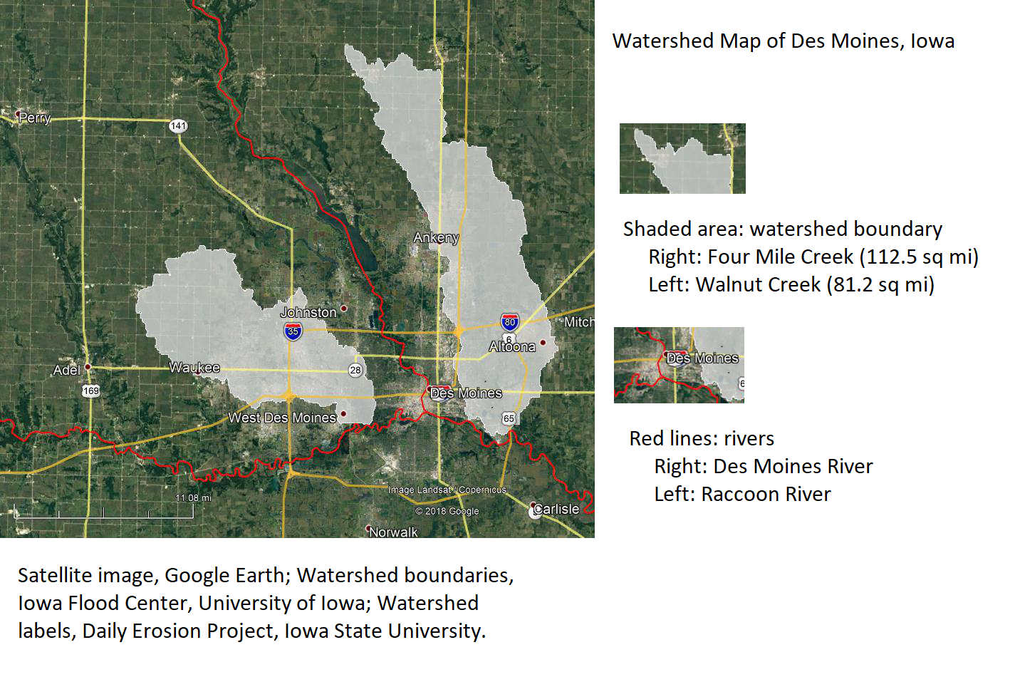
From a sustainability standpoint the report recommends a watershed approach to flood control and emergency planning. Such an approach would require public and private support from beyond the city limits of Des Moines, particularly among upstream communities. Possible routes of cooperation might include upstream communities participating in the FEMA CRS program, which qualifies them for federal funding for floodplain management planning. Of the six Iowa cities participating in the CRS program, the only city in the Des Moines/Racoon River watershed is Des Moines. Four are in the Iowa/Cedar watershed and one is along the Mississippi River. FEMA also allows counties to participate, of which there are three in Iowa that do: Linn, Story, and Pottawattamie; with Story being the only county that shares part of a watershed with the City of Des Moines.
Finding neighboring cities and counties in the watershed would go a long way towards better flood planning and preparedness during emergencies, which is the goal of a community group that contributed to the Flood Report. The sustainability portion of the Flood Report was written in consultation with the Des Moines Citizens Task Force for Sustainability. Established by the Office of the Des Moines City Manager, the Task Force was created as part of the city’s long-term strategic plan. The Task Force’s community contact, Carolyn Ulenhake Walker, would like to see more city resources devoted to long-term planning and flood resilience. When asked how she thought the city officials could move the needle on these issues, Ulenhake Walker recommended more attention be given to watershed planning; “Because we know extreme rain events are occurring more often, the taskforce thinks watershed projects need more attention and more money.” She was also supportive of looking for like-minded stakeholders outside of the city limits. The metro-adjacent cities of Ankeny and Clive are collaborating with Des Moines on watershed planning projects for the Walnut Creek and Four Mile Creek watersheds. Additional support is being provided by officials with Polk County’s Soil and Water Conservation office in Ankeny. Although these projects are still in the developmental stages, Ulenhake Walker is optimistic the watershed approach will be successful; “[We] would like city staff to really research this topic, as well as act upon the [watersheds approach] recommendation.”
The author of the Flood Committee’s sustainability recommendations echoed the Task Force’s plea. Brian Campbell, Director of Sustainability Education at Simpson College, says that 2018 Flash Flood Report is an opportunity for the City of Des Moines to situate itself in broader conversations about sustainability and watershed planning; “Our hope would be that city leaders work to engage as broadly as possible – upstream and downstream, inside and outside Polk County.” Although a planning process involving multiple stakeholders can be painstakingly slow, Campbell is optimistic that the city can make quick progress by adopting models already in use elsewhere; “I’m not an expert in this area, but my sense is that something like the Iowa Watershed Approach (IWA) would be helpful to convene different stakeholders.” Both Campbell and Ulenhake Walker attended a fall 2018 meeting about the benefits of the IWA and incorporated their findings into the recommendations. The meeting was hosted by Des Moines-based engineering company RDG Design.
While the planning process slowly moves forward, the city has also taken short-term action. Homes in the areas hardest-hit by the June floods are being bought by the city. As of the end of 2018 the city has acquired 78 properties at a total cost of $10.5 million. Most of the properties lie along Four Mile Creek, on the city’s northeast side.
Residents interested in a watershed approach for Des Moines are encouraged to attend any regular meeting of the Citizen’s Taskforce on Sustainability. The group meets monthly, on the first and third Wednesdays, at 4:30pm. The meeting location is Ingersoll Park, at 4906 Ingersoll Ave. For more information contact Carolyn Ulenhake Walker at carolynruw@gmail.com.
 Joe Otto is the Communications Specialist for the Iowa Water Center. He is a doctoral candidate at the University of Oklahoma, where he is writing a dissertation on the history of drainage in Iowa.
Do you live in a city facing a pressing water management issue? Let the Iowa Water Center put a spotlight on it. Contact jwotto@iastate.edu for more information.
Works Cited
“2018 Flash Flood Report,” Des Moines City Council Workshop Reports. Accessed 1-9-2019. http://www.dmgov.org/Government/CityCouncil/WorkshopDocuments/20190107%20Flood%20Activity%20Report.pdf
Campbell, Brian. Director of Sustainability Education, Simpson College, personal communication, January 16, 2019.
City Manager, Office of. “Sustainability Efforts.” City of Des Moines. Accessed January 24, 2019. https://www.dmgov.org/Departments/CityManager/Pages/SustainabilityEfforts.aspx
Daily Erosion Project. Iowa State University. Accessed January 24, 2019. https://dailyerosion.org/map/#20190124//qc_precip/-94.50/42.10/6//0/
Federal Emergency Management Agency (FEMA).“October 2017 NFIP Flood Insurance Manual, 20 CRS Section” FEMA.gov. Accessed 1-9-2019. https://www.fema.gov/media-library-data/1503240360683-30b35cc754f462fe2c15d857519a71ec/20_crs_508_oct2017.pdf
Iowa Watershed Approach, Accessed January 24, 2019. https://www.iowawatershedapproach.org/
Iowa Flood Information System. Iowa Flood Center, University of Iowa. Accessed January 24, 2019. http://ifis.iowafloodcenter.org/ifis/en/app/
Ulenhake Walker, Carolyn. Community Contact for Des Moines Citizens Task Force for Sustainability, personal communication, January 15, 2019.
U.S. News and World Report. “Des Moines Spends $10.5M to Buy 78 Flood-Damaged Homes.” Accessed January 15, 2019. https://www.usnews.com/news/best-states/iowa/articles/2019-01-11/des-moines-spends-105m-to-buy-78-flood-damaged-homes
Iowa Water Center City Spotlight: Cedar Rapids
By Joe Otto, Communications Specialist at the Iowa Water Center
The City Spotlight series highlights ongoing efforts by Iowans living in cities to address water issues impacting their neighborhoods.
2019 will be a big year for flood control planning in downtown Cedar Rapids. The city’s budget for the 2020 fiscal year includes $35 to $40 million-dollars for flood protection – nearly double the amount of last year. With the 2020 fiscal year beginning on July 1 of this year, officials are actively exploring various options and drawing up plans. On top of the significant jump in local funding is an infusion of federal dollars amounting to $76 million in grants and $41 million in low-interest loans.
Already underway is the construction of a $14.2 million-dollar floodwall and pump station to protect the Quaker Oats factory, which sits downtown on the banks of the Cedar. This project was started during the previous fiscal year and is the largest and most expensive currently underway. Because rail access is crucial to the manufacturing facility, the tracks of the Union Pacific Railroad will be realigned and outfitted with a floodgate. The railroad floodgate was partially funded by a grant from the Iowa Department of Transportation.
The city’s goal is to withstand another Flood of 2008. At the present, the city prepares for floods by setting up temporary defenses: movable barriers and portable pumping stations. The long-term vision is to integrate these defenses into a more permanent system. Additional pumps at existing pumping stations would reduce the city’s reliance on portable pumps, and enable city staff to focus on other tasks during times of emergency.
Future plans include large, rolling floodgates along major streets – similar to that constructed near Birdland Park and Guthrie Ave. in downtown Des Moines after the Floods of 1993. A floodgate on 16th Ave where it spans the Cedar River would effectively link two sections of concrete wall on either side of the bridge. In the event of a flood, the gate would roll into place and seal up a vulnerable breach in the city’s flood defenses.
But the city is also committed to keeping the Cedar River connected to the downtown area. The 8th Avenue bridge is slated for replacement, which may also include pump stations, restrooms for the city’s outdoor amphitheater, a scenic overlook of the city’s riverscape, or possibly a vendor space for restaurants or shops. Upgrades to a recreational trail along the Sinclair Levee will include more benches and monuments honoring local historical figures. The city’s flood control manager, Rob Davis, has stated that the city intends to stick to its master plan, “which is not to wall us off from the river.” By incorporating economic and recreational development of the riverfront area into its flood protection planning, the city believes interaction with the Cedar River will remain a valuable attraction, despite the ongoing struggle to control its more uncontrollable elements.
Cedar Rapids has successfully directed state and federal funding streams into their downtown flood protection plans. Part of their success hinges on the city’s use of bonding and property taxes to raise matching funds from local sources – often a requirement for high-dollar, competitive grant programs. In 2018 the City Council approved a $264 million-dollar bonding plan, spread out over ten years, to raise the necessary local funds. The plan involves property tax raises of about 22 cents per year. As reported by the Cedar Rapids Gazette, the sale of these bonds will be subject to a future vote by the City Council.
Anyone interested in commenting on the planning process as it moves forward is encouraged to attend regular City Council meetings. The City Council also intends to gather public input by scheduling public hearings, which residents are also encouraged to attend. For more information contact the City Manager’s office at 319-286-5051 or email at citymanager@cedar-rapids.org.
Documentation of the city’s Stormwater Master Plan is available on the city’s website at http://www.cedar-rapids.org/local_government/departments_g_-_v/public_works/stormwater_master_plan.php#content
Joe Otto is the Communications Specialist for the Iowa Water Center. He is a doctoral candidate at the University of Oklahoma, where he is writing a dissertation on the history of drainage in Iowa.
Do you live in a city facing a pressing water management issue? Let the Iowa Water Center put a spotlight on it. Contact jwotto@iastate.edu for more information.
Works Cited:
Cedar Rapids Gazette, January 5, 2019, “Cedar Rapids flood system takes leap forward in 2019: Now with federal aid, city doubles down on making progress.”
Accessed 1-8-2019. https://www.thegazette.com/subject/news/government/cedar-rapids-flood-protection-government-funding-20190105
“Stormwater Master Plan,” City of Cedar Rapids. Accessed 1-8-2019. http://www.cedar-rapids.org/local_government/departments_g_-_v/public_works/stormwater_master_plan.php#content
Iowa Water Center City Spotlight: Mason City
By Joe Otto, Communications Specialist at the Iowa Water Center
The City Spotlight series highlights ongoing efforts by Iowans living in cities to address water issues impacting their neighborhoods.
Suburbanization in Iowa’s cities and towns has been well underway since the 1990s and beyond. Homeowners in the suburbs enjoy closer-knit neighborhoods and quieter streets, but recently residents in two subdivisions of Mason City took action to combat a lingering exposure to flooding that has recently become more problematic.
Following a wet summer of 2018, Mason City is exploring options to better combat flooding on its east side. Residents in the Asbury and Eastbrooke neighborhoods met to hear the City’s plans to help protect their homes from future flooding. Damaging floods during the summer of 2018 caused the City to explore upgrades to their storm water and drainage infrastructure that was unable to hold back the rising waters.
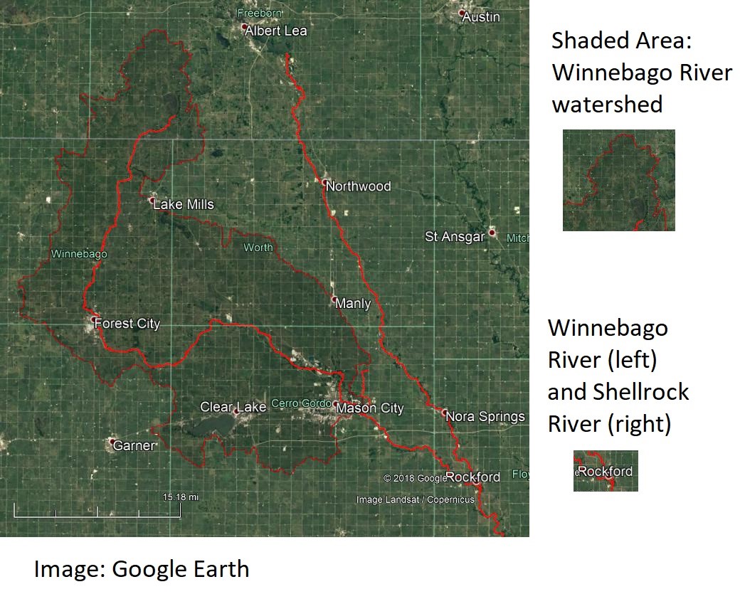
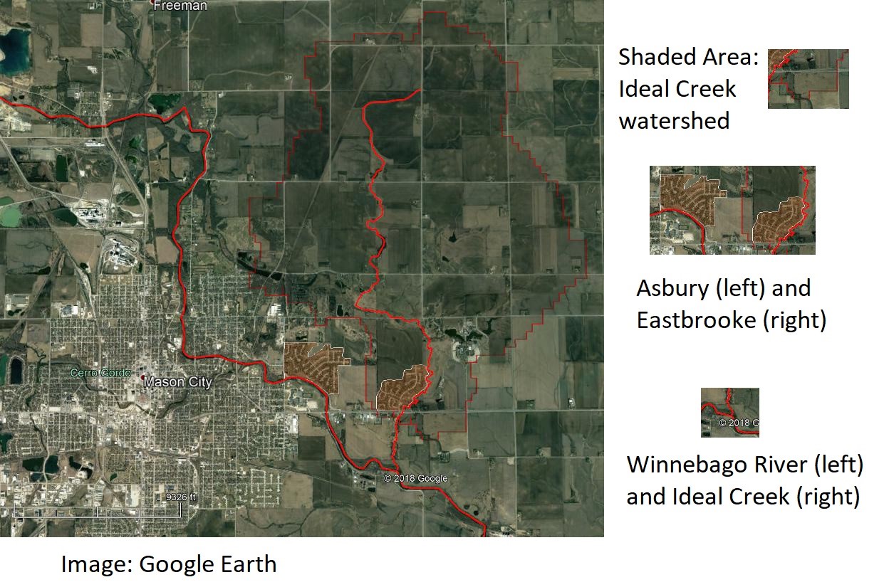
The two suburban neighborhoods are located right next to one another. Both are in the Winnebago River watershed, but only Asbury is right along the Winnebago River. Five hundred and ninety-seven square miles of land in the Winnebago river valley drains into the Asbury neighborhood, including Clear Lake and the upper course of the Winnebago, from Mason City, past Forest City and Fertile, to its source at Bear Lake in Minnesota (Iowa Flood Center). Eastbrooke, on the other hand, sits along a small branch of the Winnebago, Ideal Creek, that outlets into the river just downstream from the subdivision. The drainage area of the Ideal Creek watershed above Eastbrooke is 9.4 square miles, which spans northward as far as 305th Street in Cerro Gordo County (Iowa Flood Center). Although these watersheds are very different in size, they do share a common problem. When floodwaters threaten homeowners on the banks of the Winnebago, the river is too swollen to allow water from Ideal Creek to discharge. The result is that both neighborhoods experience flooded basements and overworked sump pumps.
Two plans are under consideration. The first is to build a new drain with sufficient capacity. The current one was built in the 1980s, before these neighborhoods existed. In the 1980s the lands in question were farmed and tiled with 16-inch drains, but when then subdivisions were formed in the 1990s the tile was abandoned and left in place. In response to complaints, in 2016 the City redirected some of the tile into a storm sewer and cleared the system of tree roots. The cost to replace the old system is about $300,000.
The second plan is for the property owners to petition their City government to form a drainage district. Under Iowa law, residents seeking relief from overflow on their lands can form a special taxing district that exists apart from the city’s general taxing structure. Property within the district is taxed to pay for new drainage systems. Option two would require close cooperation with the Cerro Gordo County Supervisors and the Mason City Council, as both have jurisdiction in drainage district matters. Other cities have followed this route, such as the City of Storm Lake in Buena Vista County. If homeowners explore this option they might consider reaching out to their neighbors to the west to learn more about the pros and cons of forming a drainage district. Another source of information is the City of Spirit Lake in Dickinson County, where a drainage district includes much of the city as well as neighboring agricultural land. Mason City officials have experience in drainage matters as well, as part of a Cerro Gordo County drainage district, No. 17, lies within the city limits on the west side. The outlet of the ditch is Chelsea Creek, just downstream from the Mason City Country Club. An area of 2 square miles drains into this district (Iowa Flood Center). This option is expected to cost at minimum $50,000 and would enable residents to more easily request and pay for future maintenance and repairs.
The problems faced by residents of Asbury and Eastbrooke show the unintended consequences of developing suburbs in flood-prone areas. Their efforts to work with local governments, both city and county, to solve these problems is laudable and may provide an example to other Iowans living in similarly-impacted areas.
City Officials commissioned the Mason City-based engineering firm of WHKS to perform the study. As first reported by KAAL-TV, the recent public meeting was held on December 5th and was part of the planning process. City Officials are accepting public comments on this project and expect to issue a final report by the end of December. Readers interested in commenting or learning more about Mason City’s planning process should contact the Mason City engineer’s office at engr@masoncity.net or 641-421-3605. To learn more about the county’s management of a drainage district that includes lands within the limits of a city, contact the Cerro Gordo County Auditor’s office at webdrainage@cgcounty.org or 641-421-3064.
Joe Otto is the Communications Specialist for the Iowa Water Center. He is a doctoral candidate at the University of Oklahoma, where he is writing a dissertation on the history of drainage in Iowa.
Do you live in a city facing a pressing water management issue? Let the Iowa Water Center put a spotlight on it. Contact jwotto@iastate.edu for more information.
Works Cited:
City of Mason City. Commissioner’s Report: Reclassification of Benefits, Drainage District No. 17. Accessed 12-10-2018. www.masoncity.net/files/documents/DDNo17CommissionersReport1191082749062617AM.pdf
City of Spirit Lake. Drainage District #22. Accessed 12-10-2018. https://www.cityofspiritlake.org/government/drainage-district-22/
City of Storm Lake. Drainage District Trustees. Accessed 12-10-2018. https://www.stormlake.org/463/Drainage-District-Trustees
Google Earth. Accessed 12-10-2018.
Iowa Flood Information System, Iowa Flood Center, University of Iowa. Accessed 12-10-2018. https://iowafloodcenter.org/
KAAL-TV Channel 6, Mason City, IA. “Mason City Residents Share Thoughts on Flood Mitigation Efforts,” Accessed 12-10-2018. https://www.kaaltv.com/news/mason-city-residents-share-thoughts-on-flood-mitigation-efforts/5169184/