We ask Dan Gilles, Water Resources Engineer from the Iowa Flood Center, the question: What is the conversion rate of cubic feet per second to gallons?
Ask a Scientist – Flooding and Crop Losses
We ask Antonio Arenas, Assistant Research Engineer at IIHR Hydroscience and Engineering, the question: What is the estimated direct crop losses due to flooding in Iowa?
Continue readingAsk a Scientist – Resilience
We ask Craig Just, Associate Professor in Civil and Environmental Engineering at the University of Iowa, the question: What is resiliency?
Continue reading2018 One Water Summit – Iowa’s Commitment
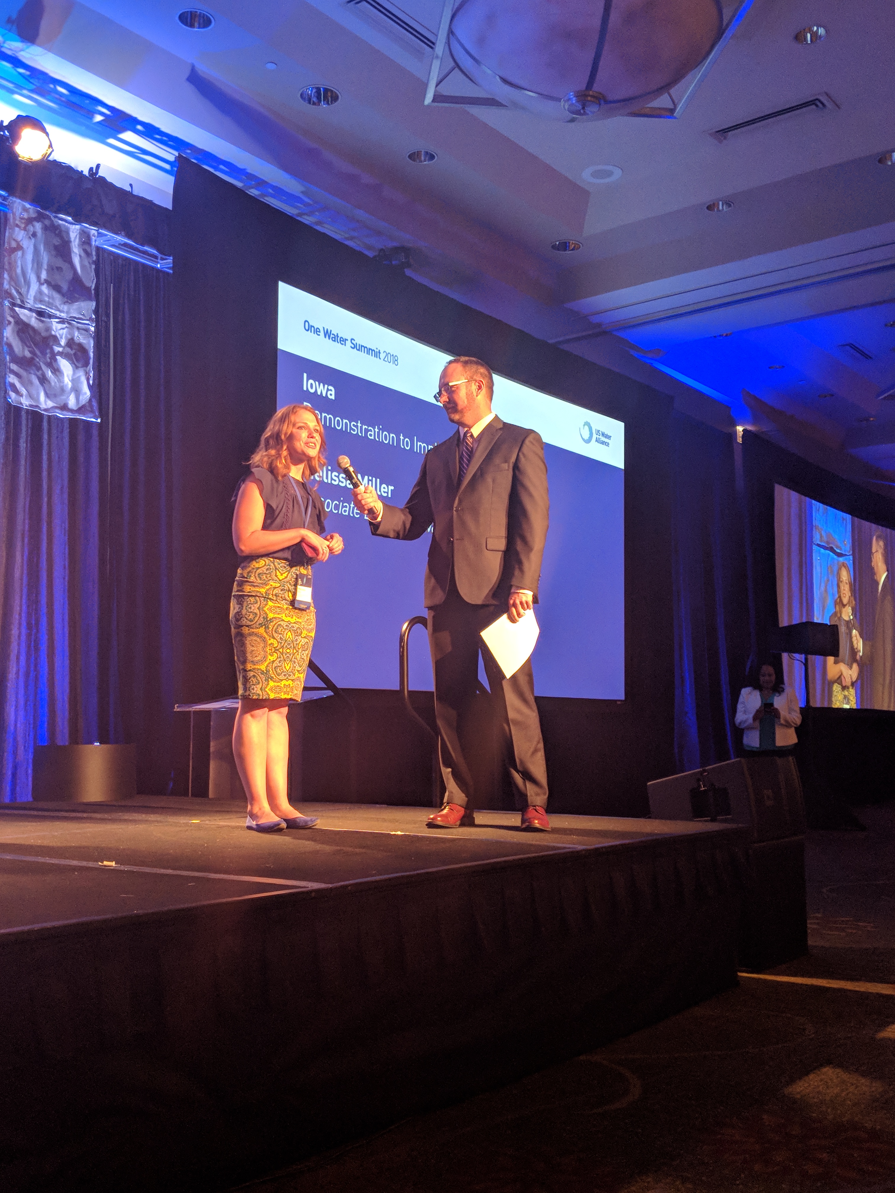
Miller presented Iowa’s commitment to water during closing remarks at the 2018 One Water Summit. Iowa had a conference delegation of over 50 people representing agencies, non-profits, and educational institutions who make an impact on water.
“Water connects us all. This core belief drives our work in Iowa, one we’ve seen in action over the last five years and one we focus on in the year to come. We celebrate the fifth year of the Iowa Nutrient Reduction Strategy, strengthened by the $97 million Iowa Watershed Approach to reduce flooding and improve water quality, as well as the Conservation Infrastructure action plan that brings together public and private sector partners to scale up those practices recommended by the science-based strategy. This next year, we commit to significant progress towards healthier watersheds as measured by conservation practices on the ground.”
-Melissa Miller, Associate Director of the Iowa Water Center
The Realms of Flood Resilience: protecting our communities
Post submitted by Craig Just, assistant professor for the Department of Civil and Environmental Engineering at the University of Iowa and Ashlee Johannes, coordinator for the Iowa Watershed Approach Flood Resilience Program.
How can we become more flood resilient?
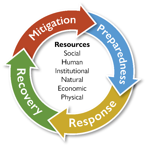 Community resilience is a recent desire for communities that face a serious disruption in their routine. But, what is resilience? A resilient community is able to mitigate, prepare for, respond to, and recover from an adverse event, including floods. The Iowa Watershed Approach (IWA) Flood Resilience Team views resilience in terms of six “resources”—social, human, institutional, natural, economic, and physical. A community’s resilience depends on its capacities in each of these areas, as well as the engagement and unity of its citizens.
During the first year of the IWA, the Flood Resilience Team trekked 10,000-miles, crisscrossing the state of Iowa and visiting diverse watershed communities to recognize their progress and understand their hurdles towards building a resilient community. In the process, our team observed a common resource that was missing in their actions: social resilience. Social resilience, at a community scale, is challenging to describe and quantify, so we have committed our focus to this topic. Our flood resilience programming has three goals that all strive towards improving social resources, and other resilience resources, for the IWA watersheds: 1) measure, visualize, and communicate flood resilience resources; 2) enhance flood resilience content in formal watershed plans; and 3) improve social resources of flood resilience.
A critical action for the Flood Resilience Team is the creation of interactive maps that display social vulnerability at the intersections of flood risk for each IWA watershed. With this information, watershed representatives can identify areas of high social vulnerability (or lower resilience). Furthermore, users will be able to pinpoint the underlying drivers of the vulnerable area (e.g., prominently low-income neighborhoods, people with disabilities, large children population) for targeted outreach and emergency response purposes. We will also empower community planners to use this information to implement flood mitigation strategies that protect socially vulnerable populations.
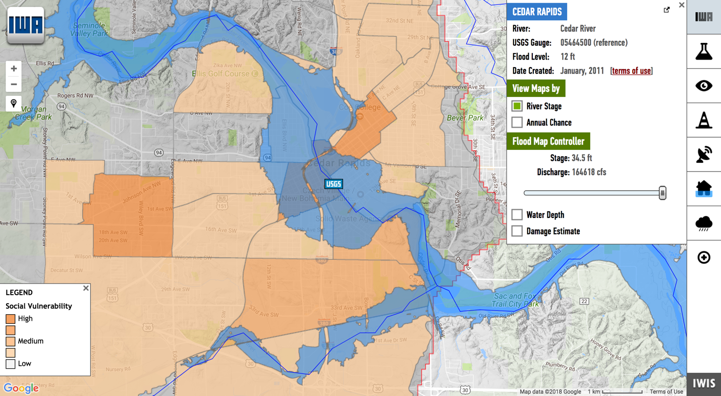
With assistance from IWA partners, the Flood Resilience Team is contributing to flood mitigation planning by connecting hazard mitigation and watershed plans to expand opportunities for other funding sources. To facilitate this process, damage and loss estimates to structures and their contents will be available online. This information, in addition to the social vulnerability maps, will be useful for emergency response, outreach, and planning purposes. To view the most recent version of these digital maps, visit: http://iwa.iowawis.org/.
Learn more about the IWA Flood Resilience Program at the Annual Iowa Water Conference on March 21-22 at the Scheman Building at Iowa State University in Ames. Lead presenter Ashlee Johannes will host a breakout session about the evolution of the flood resilience program and building a more resilient state.
Together, we can make our watershed communities more flood resilient. For more information about the IWA Flood Resilience Program, visit: http://www.iowawatershedapproach.org/programs/resilience/.
About the Authors:
Craig Just, PhD, is assistant professor for the Department of Civil and Environmental Engineering at the University of Iowa (UI). He is also an affiliate of the UI’s Water Sustainability Initiative. As the team leader of the Iowa Watershed Approach Flood Resilience Program, he develops and manages resilience programming actions and products.
Ashlee Johannes, MS, is the coordinator for the Iowa Watershed Approach Flood Resilience Program. She assists with product development, facilitates communication of the resilience programming activities, and fosters engagement with IWA watershed groups, partnering organizations, and other stakeholders.
Notes from a newly forming WMA: Developing a replicable program with the Iowa Watershed Approach
In September, Iowa Water Center staff were spread across the state to attend the fall meetings of several Watershed Management Authorities (WMAs). One of these meetings was the North Raccoon Watershed Management Coalition (NRWMC), held on September 20th in Lake City, Iowa (whose town welcome sign proudly proclaims they have “everything but a lake!”).
The nine different watersheds in the Iowa Watershed Approach started at varying stages of WMA development. North Raccoon was one of those in the beginning stages that did not have a WMA prior to the Iowa Watershed Approach start date. The 28E agreement was filed in the spring of 2017, and this was the second quarterly meeting since that time. Because the group is so new, the topics touched on at this meeting may be helpful to other newly forming WMAs, whether they are part of the Iowa Watershed Approach project or not.
Managing a large group
One of the challenges for NRWMC is that the sheer size of the watershed leads to many potential entities (cities, counties, and Soil and Water Conservation Districts) for the 28E agreement. NRWMC did an excellent job securing participation of 36 entities, but with each entity receiving a board seat (as is common practice with WMAs), it can be difficult to find a meeting time with enough board members to secure a quorum. To address this issue, board members can participate by phone, or designate proxies.
One of the first actions the NRWMC needs to take is hiring a watershed coordinator. A watershed coordinator is a jack-of-all-trades that coordinates the WMA board as well as WMA-related activities in the watershed. NRWMC designated a subcommittee for hiring at a previous meeting, but the entire coalition will need to approve the hiring of the individual recommended by the subcommittee. With only meeting quarterly and the necessity of a high number of members required for a quorum, NRWMC chose to schedule a telephonic board meeting once the subcommittee had prepared their recommendation.
Board education
Like other WMAs, NRWMC board members are not necessarily experts in watershed management. Board chair Mark Hanson took some time at this meeting to give an overview of the history of the watershed. As a new group, it is beneficial for the board to pause and reflect on what has shaped the watershed in the past – both recent land use and weather events as well as the historical geology of the region.
This information segued nicely into a presentation by Tony Loeser, Water Resources Engineer at IIHR Hydroscience and Engineering at the University of Iowa, as he explained what NRWMC could expect from the expansive hydrologic assessment being conducted by his group. Included in the hydrologic assessment:
- climate and historical streamflow assessments (including average rainfall, streamflow patterns, floods of record, and abnormal weather patterns)
- data sets that describe watershed characteristics (geology and soils, land use, BMP mapping, topography, unique characteristics that contribute to the way water moves in the watershed)
- instruments/data record (streamflow and rainfall)
- watershed scaled hydrologic model runs that are compared with observed responses to rainfall events
Tony’s presentation did a great job of outlining the how, the why, and the “so what?” of the hydrologic assessment. Even though NRWMC won’t have those results for several months (all that data gathering and analysis takes time!), understanding what’s to come helps this new group in their understanding of the watershed management process.
One final observation: the power of complete and concise meeting minutes cannot be overstated (especially with a 36-member board). Hats off to the board secretary for judicious recording of meeting happenings (including documentation of University of Iowa Center for Evaluation and Assessment Julie Kearney’s predictive score for the Iowa-Penn State game!).
This is part three in a series on the Iowa Watershed Approach. Read our other coverage below:
Working with your Watershed Partners – Part 1
Getting to know your Watershed Pt. 2

Melissa Miller is the associate director of the Iowa Water Center. She earned a BS in Kinesiology from Iowa State University with an emphasis in Community and Public Health. She is currently pursuing a MS degree in Community Development with an emphasis in Natural Resource Management, also from Iowa State University.
Getting to know your Watershed Pt. 2
Digging up the data on the Iowa Watershed Approach
Before putting together a comprehensive watershed plan, a watershed community has to know the current state of their watershed. Not only this, but if the project involves federal funding, they must also examine how any proposed changes could positively or negatively affect the watershed. This is in accordance with the National Environmental Policy Act (NEPA), a federal law enacted in 1970, which requires an assessment of the potential environmental effects of a federal project.
The Iowa Watershed Approach is a federally funded project from the Department of Housing and Urban Development. Work conducted with funding from this department must also align with the HUDs standards for NEPA review and compliance found in 2 Code of Federal Regulations (CFR) Part 58. This is to ensure that no substantial, unwarranted harm is caused to a community, ecological habitat, or to a historic site.
Environmental assessments will occur in two phases for the Iowa Watershed Approach: a programmatic review of potential environmental impacts, and then a site-specific assessment at specific locations before starting a conservation implementation project.
What are these assessments looking at?
Phase one assessment will examine the items listed below. Some of them cannot be resolved until a specific site has been identified, thus the Phase 2 site-specific assessment. Others are not carried forward in the Phase 2 analysis because the project – overall and at the site-specific level – is in compliance.
- Air Quality
- Coastal Zone Management
- Environmental Justice
- Explosive and Flammable Operations
- Noise
- Water Quality (Sole-source aquifers)
- Wild and Scenic Rivers
- Airport Hazards
- Contamination and Toxic Substances
- Endangered Species
- Farmland Protection
- Floodplain Management
- Historic Preservation
- Wetland Protection
Why have all of these rules and regulations?
Because it is the responsible thing to do. This project is making changes to the landscape, and although all the proposed changes are identified as conservation practices, project partners still have to be responsible stewards of the land by evaluating potential environmental impacts and the cumulative effects they may have over time on our environment.
What has been done so far?
Right now, environmental assessments are being drafted for the nine watersheds identified for the Iowa Watershed Approach. They will be available for a public review/comment period, and then the assessments will be approved and adopted by the County Board of Supervisors for each watershed. The assessment will then be available as a public document.
What is next?
After an environmental assessment becomes a public document, the information will be incorporated into a watershed plan with other information contributed by public institutions in Iowa to identify areas for specific conservation projects. Once a specific site has been identified, a more-focused environmental review of the subject site will be initiated. This review is developed out of issues and concerns identified in the Phase 1 environmental assessment. Although it may seem like a long process, this is to prevent any unintended consequences or negative impact on the land, animals, or people in the future.
This is a multi-part series exploring the process of how Watershed Management Authorities and other entities are organizing and making a positive difference in Iowa through the Iowa Watershed Approach.
Start Here: Pt. 1 Working with your Watershed Partners

Hanna Bates is the Program Assistant at the Iowa Water Center. She has a MS in Sociology and Sustainable Agriculture from Iowa State University. She is also an alumna of the University of Iowa for her undergraduate degree.
Iowa Watershed Management Authorities: Notes from the Statewide WMA Meeting

Post submitted by Melissa Miller, Associate Director of the Iowa Water Center
At a recent Iowa Watershed Approach meeting, I introduced myself (half-jokingly) as the president of the Watershed Management Authority Fan Club. As evidenced by my post last fall after a trip to the Cedar River Watershed Coalition meeting, I am a strong supporter of a watershed approach to natural resource management. Naturally, Watershed Management Authorities (WMAs) are a recipient of my affection.
A brief overview for those not familiar with WMAs: Watershed Management Authorities are a state of Iowa-recognized mechanism for encouraging the collaboration of the different communities within a watershed and enacting watershed based planning, including adoption of conservation practices that mitigate flooding and improve water quality. WMAs were first introduced in Iowa in 2010 when Iowa code 466B was enacted. Major initiatives of this chapter include the formation of the Watershed Resources Coordinating Council (WRCC), Watershed Planning Action Committee (WPAC), the Water Quality Initiative (WQI), and WMAs. There are currently 17 WMAs in the state, with at least five more on deck for formation.
At a statewide WMA meeting on February 7, 2017, representatives from those WMAs gathered in Dubuque, Iowa to give updates and to talk strategy, successes, and collaboration. Mary Beth Stevenson with the Iowa Department of Natural Resources (IDNR) kicked off the afternoon with some fun facts about WMAs, including:
- 17 WMAs have received funding for planning or implementation through IDNR, Iowa Department of Ag and Land Stewardship, or the Iowa Watersheds Project or the Iowa Watershed Approach (two rounds of grant funding from the U.S. Dept. of Housing and Urban Development)
- 15 WMAs currently have funding at some level
- 10 WMAs are funded at a level with enough money for full-time staff and implementation
- 12 WMAs have or will have some level of paid staff, even if just part-time, funded locally and/or through grant funds
This is a promising start for WMAs as a successful vehicle for watershed management. Even more promising were the updates from the WMAs. Everyone had something to report from across the state. Indian Creek, one of the original six WMAs in 2012, is looking to hire a coordinator and completed an annual review that is turning into a strategic plan. Turkey River WMA, one of the “original HUD” projects succeeded in influencing policy in all participating political subdivisions (and achieved a 5% flood reduction in Otter Creek with the construction of 29 well-placed structures). In the Walnut Creek WMA a soil and water conservation district staff member found a lamprey (nearly extinct) in a CREP wetland. The Maquoketa River is also in the process of forming a WMA, not because they have outside funding, but simply because they have a group of interested citizens that recognize the benefits of working together.
These are just a few updates of many. My pen could hardly keep up and I couldn’t keep from asking questions. It is extremely energizing to be in a room full of people sharing ideas, concerns and solutions, and I wanted to learn all that I could. After the updates, Polk County WMA Coordinator John Swanson presented the unique activities happening in his part of the state (we will feature that presentation in its own post in the near future). We finished by breaking out into small groups to talk about how to keep WMA momentum going, establishing a WMA coordinator/staff position, watershed plan development and assessment, and how to structure a WMA collaborative group that communicates regularly to move all WMAs forward.
Citizen engagement is critical to the success of watershed management. I will leave you today with a challenge: find the WMA nearest you, even if you don’t live in that watershed, and attend a quarterly meeting. After you attend, you may just want to join my Watershed Management Authority Fan Club.
When it comes to water…

From Melissa Miller, Iowa Water Center Associate Director
What a difference a week makes. Last Friday, my family and I made a lunch and relaxation stop in Elkader on our way to Wisconsin for a weekend getaway. My girls love water, so we walked over the Keystone Bridge for a good look.

Hana, 3, and May, 5 pose near the Turkey River in Elkader on 8/19/16.
Just a week later, Elkader and other Northeast Iowa residents are dealing with severe flooding from torrential downpours earlier in the week that dumped as much as 8″ of rain in some areas, causing damage to homes, businesses, and even killing one person swept away in the flash floods. Some residents had to evacuate their homes and take shelter elsewhere (including fish!). The water that makes these communities peaceful, beautiful places to live and visit can also pose severe challenges.
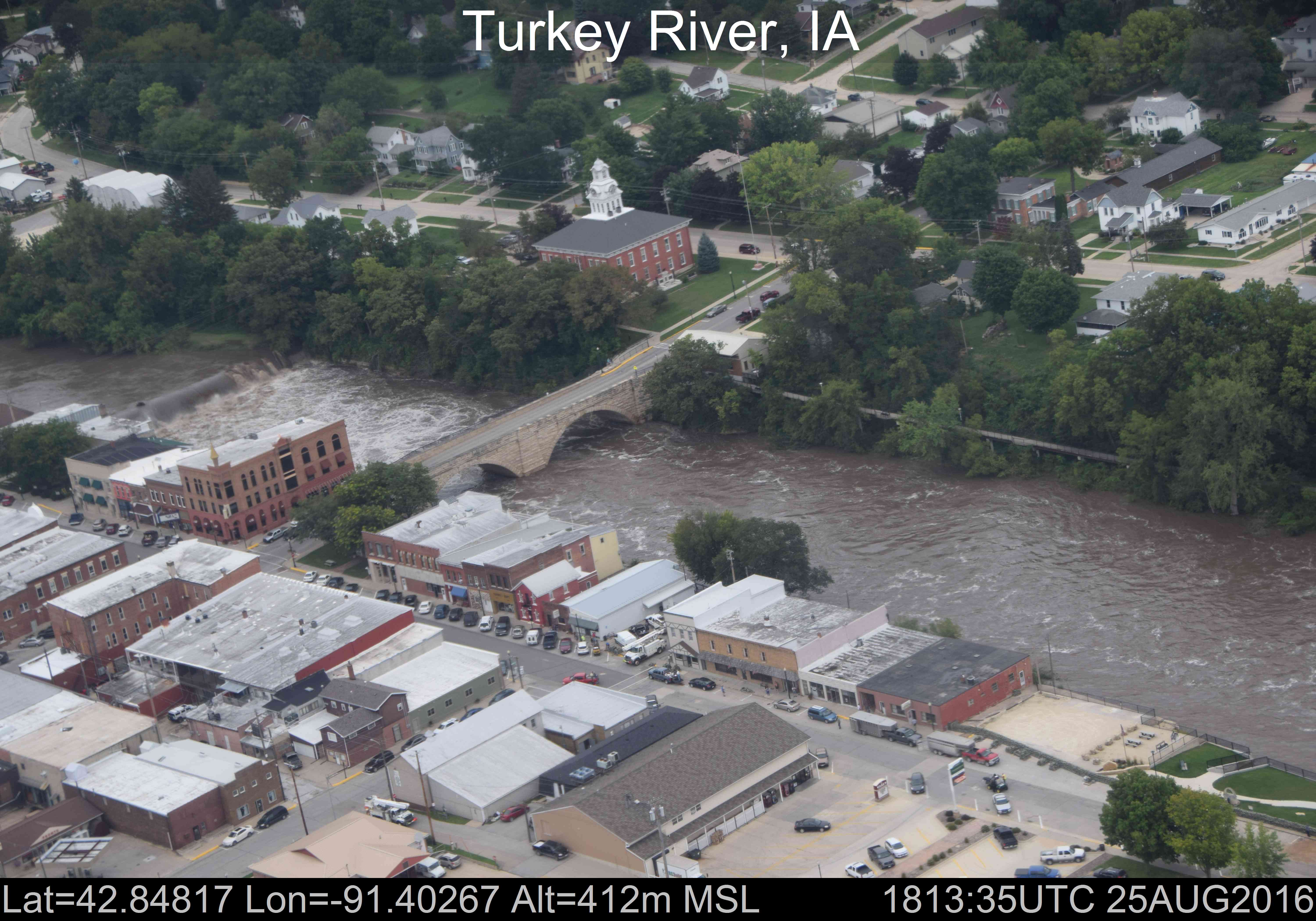
Flooding of the Turkey River in downtown Elkader as taken by NOAA’s National Operational Hydrologic Remote Sensing Center’s Airborne Snow Survey airplanes.
This storm is a solemn reminder of the power of water and the importance of studying it. Our seed grant RFP will be released soon, and this year we are partnering with other Water Resources Research Institutes in the Mississippi and Ohio River Basins to share knowledge so that we’re advancing our understanding together. In addition, the Iowa Watershed Approach has already begun work in communities to help address flood and water quality risks and increase community resiliency to events like the ones this week. Related to flooding, up-to-date flood information is available through the Iowa Flood Information System (IFIS).
IWC’s overarching goal is to improve management of water resources. “Management” might not be the best term, because in many cases, water (and nature) does what it will. There’s a parallel between “managing” water and “managing” children – no matter what you want out of it, the true nature of the water (and the child) will always rise up.
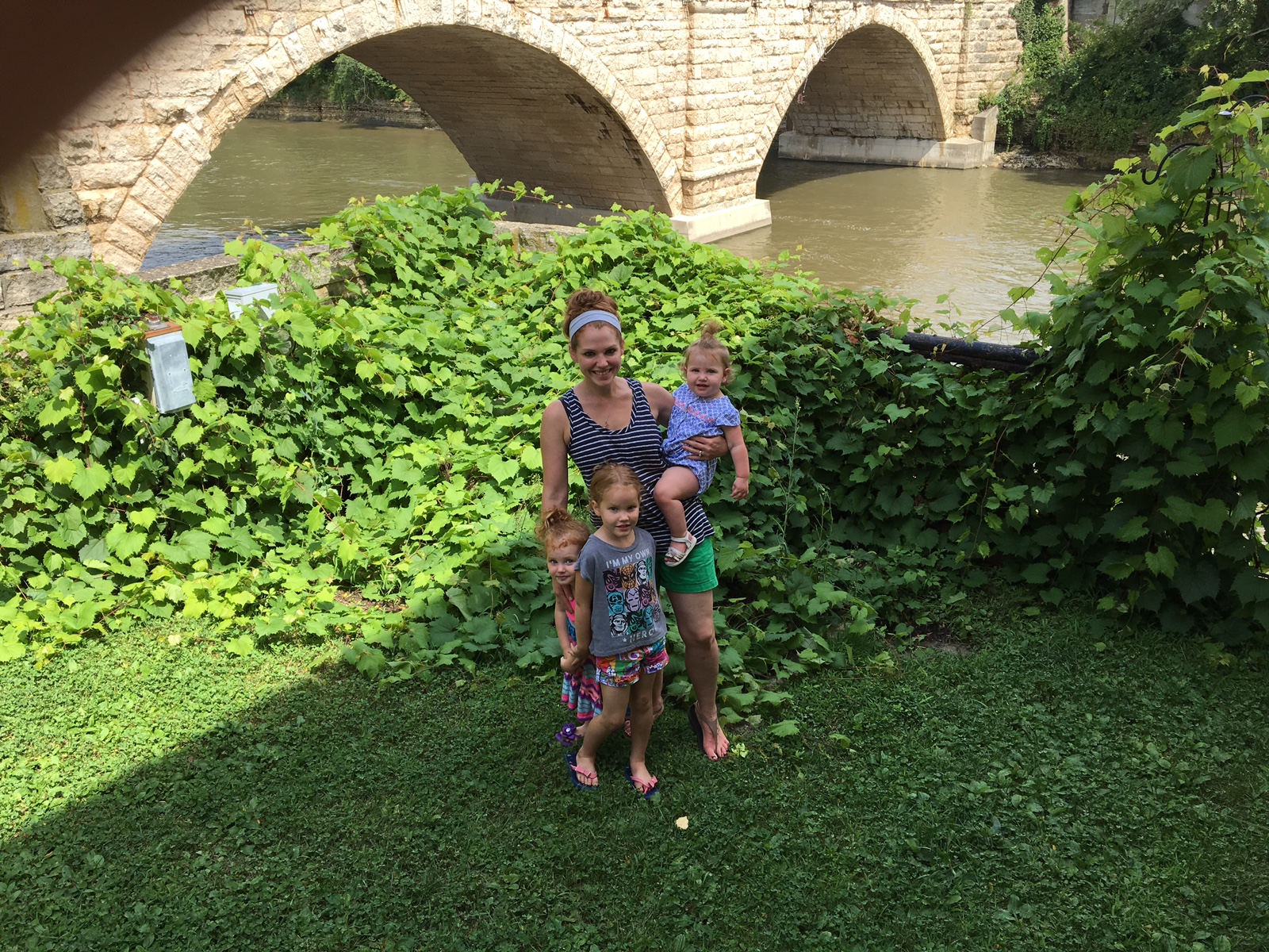
One of many attempts at a “nice” family picture at the Keystone Bridge. Getting kids to look at the camera with serene smiles can be as difficult as telling a river or a rain cloud exactly where to run or when to empty.