Post originally appeared on the Iowa Learning Farms website.
Today’s guest post was provided by Adam Wilke ISU Extension and Outreach Water Specialist.
The Iowa Watershed Approach (IWA) is a new five-year project focused on addressing factors associated with flood disasters in the state of Iowa. The IWA project will also provide benefits of improved water quality by implementing conservation practices outlined in the Iowa Nutrient Reduction Strategy.

The “HUD Project,” as it is commonly referred, was awarded $96.9 million by the U.S. Department of Housing and Urban Development (HUD). The National Disaster Resilience Competition provided $1 billion to communities that have experienced recent significant natural disasters, including Iowa’s three flood-related Presidential Disaster Declarations in 2013. Iowans remember the devastating floods of 2008 and 1993, and some are still working to repair damage from September 2016 flooding.
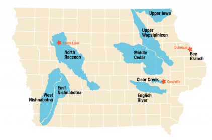
The IWA focuses on nine watersheds throughout the state, representing varying soil types, topographic regions, and land uses. These watersheds were prioritized as regions that have been most impacted and distressed from previous flood events and have unmet recovery needs. The IWA is a vision for both rural and urban resilience, and three cities (Storm Lake, Coralville, and Dubuque) are priority areas for the project.
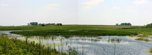
Previous efforts to address flooding impacts were piloted through the Iowa Watersheds Project in five watersheds throughout the state in 2010. By 2016, over 65 constructed practices—such as ponds, wetlands, and terraces—have been completed.

The theme of year one is “The Iowa Watershed Approach: A Visions for Iowa’s Future Under Changing Hydrologic Conditions.” Climate science indicates that annual average precipitation in Iowa has trended upward over the last 100 years and extreme precipitation events (more than 1.25 inches per day) have increased throughout the state. University of Iowa research of 774 U.S. Geological Survey stream gauges found an upward trend in frequency of flooding throughout the Central U.S. over the past 50 years. This has contributed to crop loss and destruction of infrastructure, such as homes, roads, and bridges.
The IWA will work to achieve six specific outcomes:
- Reduce flood risk
- Improve water quality
- Increase flood resilience
- Engage stakeholders through collaboration and outreach/education
- Improve quality of life and health, especially for susceptible populations
- Develop a program that is scalable and replicable throughout the Midwest and the United States
The IWA focuses on innovative in-field and edge-of-field practices to reduce flood potential and decrease nutrient concentration in surface water. The practices include:
• Wetland Construction • Farm Ponds
• Storm Water Detention Basins • Terraces
• Sediment Detention Basins • Floodplain Restoration
• Channel Bank Stabilization • Buffer Strips
• Saturated Buffers • Perennial Cover
• Oxbow Restoration • Bioreactors
• Prairie STRIPS
The IWA project creates Watershed Management Authorities (WMA) and these organizations allow for a broad range of stakeholders—including scientists, state agencies, counties, municipalities, farmers, and citizens—to organize and work towards the common goals of flood reduction and water quality improvement. Some watersheds, such as the Middle Cedar, have established WMAs, while others are beginning the formation process.
Stream gauges will provide data for the Iowa Flood Center to conduct hydrological assessments in each watershed and allow researchers to assess risks associated with flooding and water quality, including developing and evaluating future scenarios to maximize results from project resources.
WMA will use these findings to best select eligible subwatersheds at the HUC 12 (Hydrologic Unit Code) scale and prioritize implementation of constructed projects. Stakeholder inputs, watershed plans, and hydrological assessments will guide the WMAs in selecting the most beneficial practices and appropriate locations.

This project combines the strengths and efforts of Iowa State University Extension and Outreach, the Iowa Nutrient Research Center, and the Daily Erosion Project by the Iowa Water Center to achieve these goals. The IWA is a new way to think about the movement of water across the Iowa landscape. One of the most important pieces of completing such a large and complicated project is to ensure stakeholder engagement throughout the project. We look forward to hearing your questions, thoughts, and concerns as we all seek the common goal of reducing flood disaster and ensuring water quality for generations to come.
–Adam Wilke