
Post submitted by Hanna Bates, Program Assistant for the Iowa Water Center
The soil is like a sponge that holds water so it is available when crops need it. Wetter soil at the surface prevents deeper infiltration and so water is lost as surface runoff. Not only this, but soil moisture is also a variable that influences the timing and amount of precipitation in a given area. This is due to the impact it has on the water cycle. This cycle circulates moisture from the ground through evaporation and plant transpiration to the atmosphere and back to the ground again through precipitation. Therefore, the amount of water stored in the soil can affect the amount of precipitation received during the growing season.
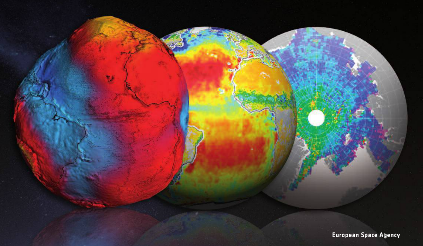
According to Hornbuckle (2014), “we enter each growing season ‘blind’ as to whether or not there will be enough soil moisture and precipitation to support productive crops.” If there were a way to document and record water storage in the soil besides field measurements, we would have a better ability to predict future weather patterns and therefore, make better field decisions. Satellite remote sensing tools such as the European Space Agency’s Soil Moisture and Ocean Salinity (SMOS) and NASA’s Moisture Active Passive (SMAP) can be used to take such measurements. Before these tools can be used to estimate water storage and improve weather and climate predictions, researchers must compare them to what is actually measured within the soil. This process of confirming accuracy of a tool is called validation.
A project led by Dr. Brian Hornbuckle, and funded by the Iowa Water Center in 2014, sought to improve and validate SMOS and SMAP in near-surface soil moisture observations of Iowa. Hornbuckle used a network of soil moisture measurements located in the South Fork Watershed as a standard to validate the accuracy of SMOS and SMAP. At each site, soil moisture and precipitation was measured.
Some of the results of this research project are presented in a 2015 article published in the Journal of Hydrometeorology. Rondinelli et al. found that SMOS and the network of soil moisture measurements detect different layers of the soil. SMOS takes measurements of the soil surface while the network observes a deeper level of soil. These results will allow scientists to better evaluate the accuracy of measurements from SMOS and SMAP and ultimately enhance our understanding of the water content of the soil surface. As noted earlier, it is this layer of the soil that determines how much precipitation is lost to surface runoff.
In a subsequent study published in 2016, Hornbuckle et al. published further results that indicate new ways of using SMOS. Researchers found that SMOS can be used to look at water in vegetation, as opposed to water in the soil. Hence SMOS might be used in the future to observe the growth and development of crops, and perhaps estimate yield and the time of harvest as opposed to conducting field surveys from the ground. It also has the potential to measure estimates of the biomass produced during the growing season, which could be useful to reach bioenergy production goals.
Research like this demonstrates that a single tool can be used in multiple ways to better understand our landscape. Not only this, but preliminary studies of SMOS also show that it is important to verify the accuracy of tools before relying on them. Like all research, the work is not done to identify all the potential uses for SMOS and SMAP. A new NASA grant, in partnership with the Iowa Flood Center, will help get researchers even closer to making satellite measurements a useful, scientific tool to understand water near the soil surface.
References
Hornbuckle, Brian K. “New Satellites for Soil Moisture: Good for Iowans!.” A Letter from the Soil & Water Conservation Club President (2014): 20.
Hornbuckle, Brian K. Jason C. Patton, Andy VanLoocke, Andrew E. Suyker, Matthew C. Roby, Victoria A. Walker, Eswar R Iyer, Daryl E. Herzmann, and Erik A. Endacott. 2016. SMOS optical thickness changes in response to the growth and development of crops, crop management, and weather. Remote Sensing Environment (180) 320-333.
Rondinelli, Wesley J., Brian K. Hornbuckle, Jason C. Patton, Michael H. Cosh, Victoria A. Walker, Benjamin D. Carr, Sally D. Logsdon. 2015. Different Rates of Soil Drying after Rainfall Are Observed by the SMOS Satellite and the South Fork in situ Soil Moisture Network. Journal of Hydrometeorology. April 2015.