Getting into Soil and Water 2020
What educational strategies encourage students to learn about soil and water?
- “Telling” is adequate.
- “Showing” is helpful.
- But “making it happen” can be the most powerful.
PEWI is a digital game-based learning (DGBL) tool created by Iowa State University that relies on simulation, one of the most powerful and reliable ways to make phenomenon happen for students in the classroom. Simulation is one of the ways to “make it happen.” Simulation fits the theory of experiential learning and other inquiry-based approaches to education. Lessons that rely on simulation show students the results of their inquiries, and involve them in making sense of the world by systematically asking good questions.
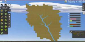
PEWI is an online game that teaches about agricultural land uses, watersheds, water quality, biodiversity, ecosystem services, and the scientific tools that land managers rely upon, such as topographic, soil, and drainage maps (Figure 1). PEWI stands for People in Ecosystems Watershed Integration (Chennault et al., 2016; Schulte et al., 2010) and has been used by teachers in middle school through university. PEWI even has a “drone” mode.
PEWI can be played at no cost at: https://www.nrem.iastate.edu/pewi/
Okay – so computer games in schools aren’t new. They have been used in classrooms by nearly 80% of middle and high school teachers (An et al., 2016), but a widespread complaint of teachers is the lack of correlation with educational subject matter (Bourgonjon, 2013). There are very few games that fit soil and water like PEWI. We’ve demonstrated PEWI to high school and community college agriculture and science teachers, and they really get it.
PEWI Land and Water
PEWI consists of a visual representation of 5,888 acres (2,382 hectare) with geophysical features combined from two Iowa landforms, the Des Moines Lobe and the Southern Iowa Drift Plain (Prior, 1991). Fifteen land uses can be applied or removed, including: corn (2 planting systems), soybeans (2 planting systems), mixed fruits and vegetables, alfalfa, grass hay, cattle (2 pasture systems), wetlands, prairie, forest, and woody bioenergy. PEWI provides maps for students to access to explain differential movement of water, nutrients, and sediment; comparative growth of vegetation; and maps to show historical flood frequency, sub-watershed boundaries, soil drainage class, soil type, topography, and crop yields. Instructors may set precipitation at seven levels from dry (24.58 in or 62.43 cm) to wet (45.10 in or 114.55 cm) or permit random assignment.
Simulation
Simulations are preferred by teachers because they allow students to “safely and cost- effectively acquire skills and attitudes which are hard to get by rote learning” (Bellotti et al.,
2013, p. 2). Simulations can be paired with instructional approaches such as collaborative and team-based learning, as well as lecture, laboratory, and field trips. Annetta (2008) showed that collaboration in simulation game playing can enhance learning.
PEWI is not a “farm simulation” where students step into the role of producer and grow crops. Instead, students in lesson plans are given watershed-level challenges like this: The current nitrate level in ppm in the PEWI River exceeds desired levels. Select the type, acreage amount, and location of land uses on the PEWI Watershed to lower the level of nitrate to an acceptable level.
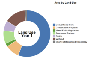
Without a simulation like PEWI, consider how difficult it would be for scientists, state and local government, and community members to generate enough evidence to add or remove a land use, such as substituting prairie for row crops; or row crops for prairie, in a particular location. The evidence, pro or con, would take years to accumulate. Monitoring is expensive and someone has to staff the equipment. Someone owns the land, which brings up economic and ethical questions. A simulation like PEWI makes the query-response process fast, easy (Figure 2), and poses fewer ethical dilemmas than for the real situation.
National Educational Standards
A simulation also fits with national standards for science, the Next Generation Science Standards (NGSS) (National Research Council [NRC], 2012). Simulation fits an NGSS practice definition of “trying things again and again but without real materials” (NRC, 2012). The standards for agricultural education, the National Agriculture, Food, and Natural Resources Standards (AFNR; National Council for Agricultural Education, 2015), also features learning by students about cycles and feedback, which are satisfied by simulation software that require students to articulate a goal and interact with PEWI to achieve it. The PEWI team has analyzed the tool for alignment to both standards. PEWI aligned with nine high school level NGSS student Performance Expectations categories. For AFNR, the PEWI evaluation provided evidence for alignment of 10 standards and 17 indicators from the areas of Environmental Service Systems, Natural Resource Systems, and Plant Systems. Release of an online Teachers Guide for PEWI is planned for the future.
Acknowledgements
Iowa State University Departments of Natural Resources Ecology and Management; Agricultural Education and Studies; and Agronomy; The McKnight Foundation; US Forest Service Northern Research Station; and USDA McIntire-Stennis Program (IOW5423, IOW5534) supported development of PEWI and the project of aligning with educational standards. We thank Katelyn Anderson, Carrie Chennault, John Tyndall, Robert Valek, John VanDyk, and science reviewers, undergraduate research assistants, and K-16 educators who contributed to PEWI’s development.
Nancy Grudens-Schuck, PhD
Associate Professor Agricultural Education and Studies
Iowa State University
Lisa A. Schulte Moore, PhD
Professor Natural Resource Ecology and Management
Iowa State University
References:
An, Y-J., L. Haynes, A. D’Alba, and F. Chumney. 2016. Using educational computer games in the classroom: Science teachers’ experiences, attitudes, perceptions, con- cerns, and support needs. Contemp. Issues Tech. Teach. Ed. 16(4): 415-433.
Bourgonjon, J., F. De Grove, D. De Smet, J. Van Looy, R. Soetaert, and M. Valcke. 2013. Acceptance of game-based learning by secondary school teachers. Computers Educ. 67: 21-35. doi:10.1016/j.compedu.2013.02.010
Chennault, C.M., L.A. Schulte, and J.C. Tyndall. 2016. People in Ecosystems Water- shed
Integration: A web-based learning tool for evaluating ecosystem service tradeoffs from watersheds. J. Soil Water Cons. 71: 31A-36A. doi:10.2489/jswc.71.2.31A
National Council for Agricultural Education (NCAE). 2015. National Agriculture, Food, and Natural Resources (AFNR) career cluster content standards, rev. 2015. Indianapolis, IN. https://thecouncil.ffa.org/afnr/
National Research Council (NRC). 2012. A framework for K-12 science education: Practices, crosscutting concepts, and core ideas. Washington, DC: NAP.
Natural Resource Ecology and Management. 2018. People in Ecosystems Watershed Integration (PEWI 3.0). Ames, IA: Iowa State University. Available at: https://www. nrem.iastate.edu/pewi/. doi: https://doi.org/10.31274/nrem-20191121-1
Schulte, L.A., J. Donahey, L. Gran, T. Isenhart, and J.C. Tyndall. 2010. People in Ecosystems Watershed Integration: A dynamic watershed tool for linking agroeco- system outputs to land use and land cover. J. Soil Water Conserv. 71(2): 31A-36A. doi:10.2489/jswc.71.2.31A